Origins of MetroGIS
Since its origin in 1995 as a concept, several hundred people representing a wide variety of agencies and organizations have been involved in the decision-making process to shape the MetroGIS collaborative. These interests include counties, cities, regional, state, and federal agencies; school districts; watershed districts; non-profit groups; private organizations; utilities; research organizations; education professionals, and private citizens.
A broad, on-going, inclusive and participatory process was used to achieve consensus on a variety of matters critical to the success of MetroGIS, including development of a mission statement, priority functions and priority common business information needs.
History and Development
The initial concept of establishing a regional GIS to serve the Twin Cities Metropolitan Region was suggested in 1995 by the Metropolitan Council
The Metropolitan Council is granted authority by the Minnesota State Legislature to manage public transportation and wastewater treatment as well as overseeing regional planning, forecasting population growth, ensuring adequate affordable housing and supporting a regional park and trails system in the Seven Metropolitan Counties. These responsibilities fit well with the need to develop and share geospatial data across the metropolitan region, however, there needed to be a substantial business need for such an ambitious effort; the need to improve the accuracy of land use data was the original impetus for data development and sharing
 Until the mid 1990s, the Metropolitan Council collected land use information through interpretation of aerial photography. However, generalized land use data collected this way no longer had the accuracy required by the Council and regional communities for the planning process.
Many of the communities had access to land use information for individual land parcels either based on county data or coded at the community level. No mechanism existed to allow the information to be shared easily by local and regional users and no standard exists which can be applied fairly across the whole region. Acquiring an accurate source for existing land use data with standard classifications is a need the Council believed could be resolved through the sharing of GIS data.
In 1994, the Council developed a strategic plan, hired staff and proposed an ambitious joint orthophotography project for 3,000 images at an estimated cost of $6,000,000, with the Council allocating $1.2 Million through 1997 in support; remaining funds were expected to come from state, federal and local organizations with an interest in the data. The concept was introduced at the Minnesota GIS/LIS Consortium Conference in September 1995. Two informational forums followed in October 1995 to gauge public support for the concept of establishing a regional GIS and for the idea of the Metropolitan Council facilitating the initiative. Strong support was found for both concepts and, subsequently, the Council officially accepted responsibility to sponsor the collaborative.
Based on feedback received, the Council revised its initial plan. In November 1995, the Council agreed to replace its ortho-imagery program with a data and cost-sharing incentive program designed to be responsive to the individual needs of each county and to support projects that promote cross-jurisdictional GIS data sharing.

One of many input sessions held in Fall 1995-Winter 1996 to define the needs and shape the work of the MetroGIS collaborative.
![]() Strategic planning with stakeholders began in December 1995 to identify the breadth of issues and opportunity that laid the foundation for what evolved into MetroGIS. Through a series of concept mapping exercises, agreement was reached on strategic issues which would be refined into a mission statement, several initial strategic design projects, and an organizational structure. Participants in the concept mapping agreed to continue to serve in an advisory capacity; this body became the MetroGIS Coordinating Committee. The Metropolitan Council formally assumed responsibility for sponsorship and maintenance of MetroGIS on February 8, 1996.
Strategic planning with stakeholders began in December 1995 to identify the breadth of issues and opportunity that laid the foundation for what evolved into MetroGIS. Through a series of concept mapping exercises, agreement was reached on strategic issues which would be refined into a mission statement, several initial strategic design projects, and an organizational structure. Participants in the concept mapping agreed to continue to serve in an advisory capacity; this body became the MetroGIS Coordinating Committee. The Metropolitan Council formally assumed responsibility for sponsorship and maintenance of MetroGIS on February 8, 1996.
Advisory teams were created by the Coordinating Committee in March-April 1996 to address the issues and identified through strategic planning including data access, data content, data policy, and data standards. Formal endorsement and the selection of a Policy Board representative from each of the Seven Metropolitan Counties and the Metropolitan Council were sought in the fall of 1996. Endorsement of MetroGIS objectives and Policy Board representatives from associations which represent metro area municipalities, school districts and watershed districts was also secured. The MetroGIS Policy Board convened for the first time on January 15, 1997.
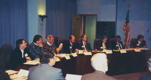
First meeting of the MetroGIS Policy Board: January 15, 1997
1997 - 2002
In October 1997, the original metrogis.org website was launched as a means of facilitating communication and disseminating information to stakeholders. During this era, MetroGIS was able to secure an agreement with a private data vendor (The Lawrence Group, later known as NCompass) to license and re-distribute high quality road centerline data to qualifying academic and government interests. This effort led to the collaborative receiving a Certificate of Commendation from Governor Arne Carlson.![]() With the awareness of the need for wider availability and usability of county-produced tax parcel data, work commenced on the initial Regional Parcel Data Pilot Project in 1998-99. By July of 2001, on the basis of the findings of Parcel Data Pilot Project, the Policy Board directed the development of a regional parcel dataset and means to distribute parcel and other geospatial data via the Internet. The Policy Board also provided its support for the continuation of MetroGIS's unincorporated organizational structure as adequate to achieve all of the functions desired by its stakeholder community.
With the awareness of the need for wider availability and usability of county-produced tax parcel data, work commenced on the initial Regional Parcel Data Pilot Project in 1998-99. By July of 2001, on the basis of the findings of Parcel Data Pilot Project, the Policy Board directed the development of a regional parcel dataset and means to distribute parcel and other geospatial data via the Internet. The Policy Board also provided its support for the continuation of MetroGIS's unincorporated organizational structure as adequate to achieve all of the functions desired by its stakeholder community.
In mid-2001, three initiatives were launched to enhance MetroGIS's functionality; these included the deployment of the MetroGIS DataFinder Café, the execution of a second generation of the data sharing agreements with the seven metro area counties and a Performance Measures Program to ensure that MetroGIS is accomplishing its goals. By 2002, a parcel data standard was developed and the first Regional Parcel Dataset was made available via license agreement to government and academic interest through MetroGIS.
2003 - 2012
The year 2003 saw the expiration of the second-generation of Data and Cost Sharing Agreements and the negotiation and execution of the third-generation of that agreement in 2004. Through the 2000s the data offerings available on the DataFinder.org resource expanded significantly as did the number of individuals and agencies accessing that data.
In 2005-06, the Metropolitan Council under took a thorough program audit of MetroGIS to assess its impact and effectiveness. Key findings of the audit revealed the many benefits including the development and strengthening of relationships between agencies using GIS in the region, fostering connectivity between GIS professionals at all levels, cost savings both to the Council and MetroGIS stakeholders for data development and availability and the Council receiving the equivalent of twenty-one (21) full time staff savings from work performed and data collected by the collaborative. The audit suggested that approach taken by MetroGIS; that of stakeholder-driven collaborative projects and activities, be expanded beyond the region and adopted as a model in state government.
Work from 2006 through 2012 focused on maintaining and expanding the availability of GIS data in the region, research attempting to quantify the value of GIS data and documentation of key data and data standards needed by the stakeholder entities.
2012 - 2019
Key achievements in the years between 2012 and 2019 included deployment of a new metrogis.org website, the enormous step of metro counties and many metro cities making their data free and open, the completion of metro-level standards for road centerline data, address point data and park and trail data, creation of regional datasets in those standards and the elevation of road, address point and parcel standards from a metro level to a state level.
MetroGIS is committed to continued research and action as to how governments at all levels-in partnership with non-profits, academia and the business community-can work together to increase the flow of data between one another, to develop needed standards and best practices, validation tools and other resources to maximize the availability of geospatial data and the effectiveness of GIS.
2020 and beyond
MetroGIS endeavors build upon its past successes to continue to identify and address the needs of its stakeholders. An underlying theme of MetroGIS’ continued work is that better data equates to better analysis and decision making which in turn leads to an improved quality of life in Minnesota.
For additional detail on the strategic development of MetroGIS, please refer to the Bryson Links page in the Archives.
Download
MetroGIS: Moving Regional GIS Data Sharing from Concept to Reality
Rick Gelbmann, Metropolitan Council
GIS Manager (1993-2013)
Timeline + Milestones
- Winter 1995
Strategic planning retreat and inputs sessions co-sponsored by LMIC (now MnGeo) and Metropolitan Council to document shared needs for region-wide data sharing - Jan-Feb 1996
A large and diverse set of geospatial data stakeholders endorse the MetroGIS vision and appoint representatives to form a policy body leading to the formal creation of MetroGIS Coordinating Committee - February 8, 1996
The Metropolitan Council formally accepts the role as the primary sponsor of MetroGIS to provide fiscal and administrative oversight and staffing; - February 27, 1996
First formal meeting of the MetroGIS Coordinating Committee is held; - March 1996
An interim Parcel Data Sharing Agreement executed between the Seven Metropolitan Counties and the Metropolitan Council - January 1997
The First Parcel Data Sharing Agreement executed between the Seven Metropolitan Counties and the Metropolitan Council; - January 15, 1997
MetroGIS Policy Board convenes for the first time; - May 1997
Execution of agreement between Metropolitan Council and NCompass Technologies for use and licensing of NCompass Technologies Street Centerline Data to government and academic interests; - October 1997
Original ‘metrogis.org’ website is launched; - Spring 1998
DataFinder.org data clearinghouse is launched; - October 9, 1998
MetroGIS receives Certificate of Commendation from Minnesota Governor Arne Carlson for efforts to provide access to high quality data to the governments of the Seven Metropolitan Counties; - June 1999
MetroGIS Policy Board Chair/Ramsey County Commissioner Victoria Reinhardt and MetroGIS Coordinator Randall Johnson testify before the U. S. House of Representatives in Washington D.C. on the value and efficacy of collaborative geospatial data development and standardization; - April 2000
MetroGIS awarded Certificate of Commendation from Governor Jesse Ventura for collaborative development of the Minnesota Land Cover Classification System (MLCCS); - 2001
MetroGIS Policy Board directs the development of a Regional Parcel Dataset solution and the means to distribute it;
MetroGIS receives $100,000 NSDI grant for development of data distribution mechanism;
MetroGIS awarded Grand Prize, International Geographic Network Challenge for web services development;
MetroGIS DataFinder.org recognized as an authorized node of the National Spatial Data Infrastructure (NSDI) - 2002
DataFinder Café is launched;
MetroGIS is awarded the MnAPA Planning Merit Award for an Outstanding Tool;
MetroGIS is awarded URISA’s Exemplary Systems in Government Award;
Regional Parcel Data standard is developed and approved;
Second-generation of the Regional Parcel Dataset Agreement is executed; - 2003
Socio-Economic Resources page is launched as part of DataFinder.org; - 2004
Third-generation of the Regional Parcel Dataset Agreement is executed; - 2005-2006
Metropolitan Council program audit of MetroGIS demonstrates the value and significant benefit of the collaborative to the stakeholders of the region; - 2009
Fourth-generation of the Regional Parcel Dataset Agreement is executed; - 2011-2012
Fifth-generation of the Regional Parcel Dataset Agreement is executed; - October 23, 2013
MetroGIS Policy Board adopts a Resolution of Support for making government-agency produced public geospatial data freely and openly available; - November 2013
Number of datasets available from the DataFinder.org clearinghouse exceeds 300; - February 11, 2014
Hennepin and Ramsey Counties adopt policy resolutions to make their public geospatial data freely and openly available; - March 25, 2014
Dakota County adopts a policy resolution to make its public geospatial data freely and openly available; - April 1, 2014
Carver County adopts a policy resolution to make its public geospatial data freely and openly available; - April 22, 2014
Anoka County adopts a policy resolution to make its public geospatial data freely and openly available; - July 7, 2014
The new 'metrogis.org' website is launched; - August 7, 2014
MetroGIS receives a State Government Innovation Award from the Humphrey School of Public Affairs at the University of Minnesota for its 'Free + Open Public Geospatial Data' initiative in 2013-2014; - November 18, 2014
Washington County adopts a policy resolution to make its public geospatial data freely and openly available; - October 6, 2015
Scott County adopts a policy resolution to make its public geospatial data freely and openly available; - December 15, 2015
After 17 years of distinguished service, the DataFinder.org geospatial data clearinghouse resource is retired; all data in its catalog becoming available from the MN Geospatial Commons (gisdata.mn.gov) - February 8, 2016
MetroGIS celebrates 20 years of operation in the Twin Cities metropolitan region - December 12, 2016
The Seven Metropolitan Counties and Metropolitan Council enact a new Memorandum of Agreement to continue the work of data development, standardization, data sharing and continued collaboration. - April 21, 2017
The first version of the MRCC road centerline dataset (standardized road data for the Seven Metropolitan Counties) is published on the Geospatial Commons. - August 29, 2018
The first version of the Metro Regional Address Point Dataset (standardized address point data for the Seven Metropolitan Counties) is published on the Geospatial Commons.